How to Read a Rural Footpath as a Sequence of Places
Read a rural footpath as a sequence of places to understand how it links village lanes, settlements and shared destinations without treating it as a shortcut.
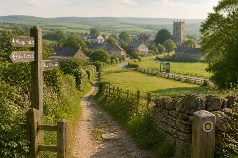
A rural footpath makes more sense when you read it as a link between places, not as a line across a map. A walk from a village to a church, bus stop or neighbouring settlement can show how everyday destinations fit together, even when no sign explains the connection.
The useful question is not what each hedge or gate might mean. It is where the route begins, which places it joins, and how those links sit within local life. You can make a clearer mental map without turning the walk into a field survey.
What places does a footpath connect?
Start with the route’s endpoints. A path may join a residential lane to a village green, connect one settlement with another, or offer a walking link to a railway station or bus stop. The connection can be more important than any single feature along the way.
Use a current local map or rights-of-way map to check the route’s public status and see what lies at either end. A footpath may look as if it continues towards a farmyard or private drive, but appearance is not permission. Follow the marked public route and use an official map when signs are unclear.
How does the route fit around daily journeys?
Some rural paths are useful for more than a weekend walk. They can link homes with a school, village shop, community hall or public transport. Notice which destinations are reachable from the path and where a walker must join a road or lane to continue.
That last connection matters. A path can end at a road without providing a safe or convenient onward route. If you are planning a journey, check the full route on a map, including road sections, crossings and any access restrictions. Do not assume that two nearby places are connected by a continuous public path.
What can you learn from the route’s sequence?
Remember a few transitions rather than trying to catalogue the entire walk. For example: village lane, open green, bridge, then a path towards the next settlement. This sequence gives you a practical sense of how the route is arranged and helps you recognise junctions when travelling in the other direction.
Imagine you are walking from a village hall towards a bus stop in the next settlement. You check a rights-of-way map first and see that the public path reaches a lane near the stop, but does not continue along the road. You follow the marked path, then use the map to assess the remaining road section. The result is a clearer decision about whether the whole journey suits your plans, rather than an assumption that the footpath runs all the way to the stop.
At junctions, look for waymarks and signs before choosing a direction. A broad track may serve farm access rather than public walking, while a less obvious path may be the designated route. If the route is blocked or its status is uncertain, do not make a new way across private land; consult the local authority’s rights-of-way information.
Which details help you understand a rural route?
- Check whether the map identifies the path as a public right of way; if it does, follow that line, and if it does not or the status is unclear, verify it with the local authority.
- Notice the named places at both ends; if they match your intended journey, continue planning the link, and if they do not, choose a route that reaches the right destination.
- Look for a waymark at a junction; if it confirms the route, follow it, and if signs are missing, pause to check a current map rather than guessing.
- Check whether the path ends at a lane or road; if it does, assess the onward section separately, and if that section is unsuitable, choose another connection.
- Notice whether a bus stop, station or village service is actually reachable from the mapped line; if it is, use that link in your plan, and if it is not, do not count it as a direct route.
- Check for signs of a temporary closure or obstruction; if an official diversion is posted, follow it, and if no route is clear, turn back or seek current local guidance.
What should you check before relying on a footpath?
Can a public footpath lead through private land?
Yes. A public right of way can cross private land while allowing passage along the designated route. Stay on that route and follow any local signs or instructions.
How do I check where a rural footpath goes?
Use a current rights-of-way map or local authority mapping, then compare it with waymarks on the ground. If the two appear to differ, seek current local information rather than choosing a convenient-looking track.
Does a footpath always provide a useful link between villages?
No. It may connect only part of the way, with a road section or another path needed to reach the destination. Check the entire journey, not just the path shown between two points.
Is it worth identifying every feature along the route?
Usually not. A few clear links and junctions are enough to understand how the walk fits with nearby places; identifying every gate or boundary adds little to that picture.
How can a return walk sharpen your mental map?
On the way back, notice which junctions are easier to recognise from the opposite direction. A path that seemed obvious on the outward walk may be less so when approaching from a lane. Waymarks and a current map remain more reliable than memory, particularly where several tracks meet.
For searches such as how to read a rural footpath, the most useful answer is to trace the route’s connections: its starting place, its destination, and any gaps between the public path and the journey you actually want to make. That simple check can prevent a pleasant walk from ending at the wrong lane.
A path becomes part of local knowledge when you know not only where it runs, but what it lets people reach. Keep that connection in mind, and the map starts to describe a community rather than merely a walk.