A Field-Edge Walk After Harvest
A field-edge walk after harvest can reveal how a familiar landscape is organised, using gates, lanes and working sounds as clues without entering fields.
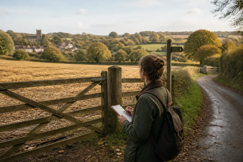
A field-edge walk after harvest can reveal how a farm landscape is organised, not merely what remains on the ground. From a permitted route, gates, lanes and working sounds offer clues about how people move through the place.
Imagine that Rowan has a free autumn afternoon and a familiar public path beside a harvested field. Rather than studying stubble or hedge plants, Rowan wants to understand how the route connects the village to working land. A local rights-of-way map, a notebook and a pencil are enough. The aim is to notice relationships between the path, entrances and nearby activity, without treating a guess as a fact.
How does a field-edge walk reveal connections?
Begin with the route itself. Does it link two lanes, pass a farm entrance or continue towards a bridge or settlement? A path can be both a walking route and part of the landscape’s everyday organisation. Its position may suggest a connection, but it does not explain who uses it or why.
Rowan checks the mapped line before setting off and notes where it meets a lane. At a safe stopping place, Rowan sketches the path as a line and marks visible junctions, gates and signs. The sketch records what can be seen; it does not assign ownership, access rights or purpose to features beyond the evidence.
What is not worth the effort? Trying to infer the whole history of a farm from one boundary or entrance. A neat story can form quickly, but a short walk rarely supplies enough evidence to support it.
What do gates and lanes suggest?
Entrances show where routes meet working spaces. A wide gateway beside a lane may be used by farm vehicles, while a stile or narrow gate may mark a pedestrian crossing. These are visible distinctions, not proof of a particular schedule or use. Give working entrances room and avoid stopping where someone needs to pass.
Look for how the path meets the lane: does it join at a bend, run parallel for a stretch or cross at a clear point? Note signs and surface changes, such as gravel giving way to grass. Rowan records “path joins lane beside a wide gate” rather than “this is the main farm entrance”. The first is an observation; the second claims more than the view can establish.
If traffic or farm activity makes a section uncomfortable, Rowan checks for a mapped alternative or turns back. A field margin is not an improvised diversion simply because it looks convenient.
How can you read the route without overclaiming?
Use a simple observation-and-decision list. Each item begins with something visible or audible, then sets a practical response:
- Check whether the map and signs agree at the route entrance; if they do, follow the marked line, but if they do not, stop and check an authoritative local access map before continuing.
- Notice whether a gate is being used or a vehicle is approaching; if the entrance is clear, pass without lingering, but if activity blocks it, wait at a safe distance or turn back.
- Look for a sign directing walkers elsewhere; if it gives a clear alternative, follow it, but if the instruction is unclear, do not invent a new route and seek reliable local guidance.
- Check whether the path surface is firm enough for your footwear; if it is, continue cautiously, but if it is slippery or impassable, return by the permitted route or use a mapped alternative.
- Notice whether a lane has traffic and a safe place to pause; if it does, stop there to make notes, but if it does not, keep moving to a safer stopping point.
- Listen for machinery or livestock close to the route; if the way remains clear, pass quietly and give them space, but if it feels unsafe, withdraw along the public route.
This approach keeps the walk practical. The map helps with access; the notebook helps separate what Rowan observed from what Rowan merely suspects. There is no need to photograph people, workers or private yards.
What questions help make sense of the walk?
Can you use a farm lane as a walking route?
Only if it is a public right of way or access is otherwise permitted. A lane’s appearance does not establish public access, so check a reliable local rights-of-way map and follow signs.
What should you record at a gateway?
Note visible details such as its position beside the path, signs and whether activity is taking place. Leave questions of ownership, purpose and regular use unanswered unless you have reliable information.
How should you respond to a temporary diversion?
Follow clear, legitimate directions for the route and check the local access information if the signs conflict or leave the way uncertain. Do not cross a field or use a private track as a shortcut.
What is useful to take on the walk?
Carry a route map or phone, weather-suitable clothing and footwear suited to the path. A small notebook is handy for recording junctions, signs and observations without stopping in a working entrance.
How might a short walk change your map?
Say Rowan’s map shows a path joining a lane near a gate, but gives little detail about the junction. Rowan checks the mapped line at the start, follows it to the meeting point, waits until the entrance is clear, then writes “footpath meets lane beside wide gate; sign points back towards village”. On returning, Rowan compares the note with the map and marks the junction as a useful landmark, not as proof of who uses the gate. The result is a more practical route note, with the uncertainty left visible.
A field-edge walk after harvest is useful when it helps you understand where a path leads and how it meets the surrounding lanes. Keep observations specific, check access rather than assuming it, and let the map show what it can. The best note may be a modest one: a junction is easier to find than it looked from the other direction.